Maximizing Sites with Trimble: A Comprehensive Guide
December 19, 2023
Trimble’s WorksManager Streamlines Project Management
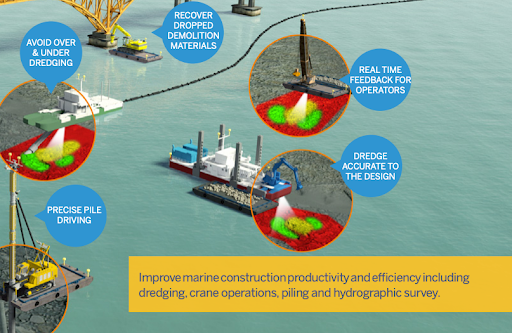
March 22, 2024Marine construction is a complex and critical industry that plays a pivotal role in shaping our world. From building ports and canals to maintaining vital infrastructure, marine construction projects are monumental undertakings that demand precision, efficiency, and innovation.
In this rapidly evolving field, one technology has emerged as a game-changer: real-time 3D visualization.
Unveiling the Power of Real-Time 3D Visualization
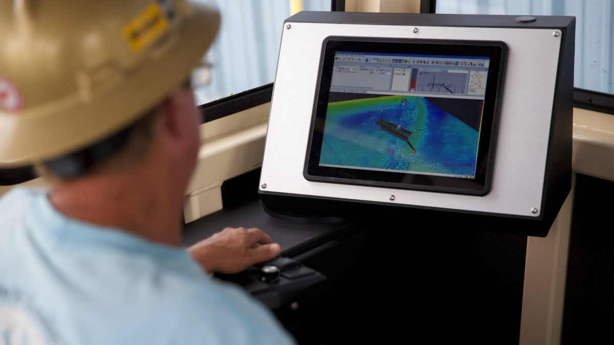
Real-time 3D visualization is not just a fancy term; it represents a groundbreaking shift in the way marine construction projects are executed. It offers a dynamic, live view of the construction site, enabling operators to monitor, adjust and optimize their operations with unprecedented precision.
DREDGE: Enhancing Precision in Dredging
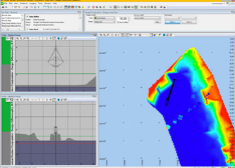
Dredging is a fundamental activity in marine construction, involving the removal of sediment and debris from water bodies to create navigable channels and berthing areas. Real-time 3D visualization is revolutionizing this process by optimizing various dredging techniques such as cutter suction dredging, bucket dredging, hydraulic excavator dredging and wire crane clamshell dredging.
Visualizing and Monitoring
One of the key advantages of real-time 3D visualization in dredging is the ability to visualize and monitor crucial components. Operators can now track the angle and position of the bucket, dredge arm ladder and cutterhead with precision. This real-time view allows operators to clean up the site before moving the barge, ensuring the highest level of accuracy.
Improved Surface Accuracy
Real-time 3D visualization technology has the power to significantly improve surface accuracy during dredging operations. By comparing the design model with the actual construction progress in ‘as-building,’ operators can make real-time adjustments, ensuring that the project stays on track and meets the required specifications.
Accelerated Productivity
In addition to accuracy, real-time 3D visualization accelerates productivity and boosts operator confidence. Knowing that they have a live view of the construction site at their disposal empowers operators to work efficiently and make informed decisions in real-time.
Empowering Operators
Furthermore, this technology equips operators with the tools they need to enhance their productivity. It provides insights and data that enable operators to continually improve their performance, resulting in more efficient and effective dredging operations.
CONSTRUCT: Precision in Construction Applications
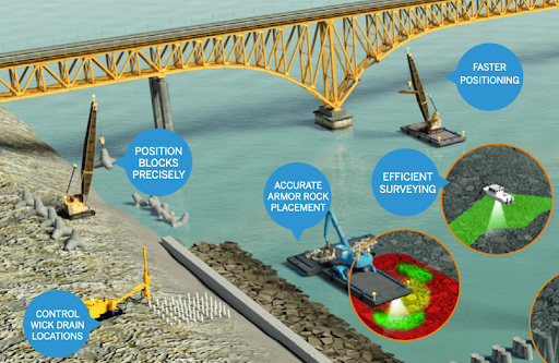
Real-time 3D visualization isn’t limited to dredging; it also plays a crucial role in optimizing construction applications. Whether it’s piling, rock placement, caisson or block placement, this technology offers robust and reliable solutions that maximize uptime and efficiency.
Real-Time View
Construction operators benefit from a real-time view of the excavator, crane and barge in both plan and profile views. This comprehensive view includes critical data such as survey and design depths, ensuring that operations are carried out with precision.
Supporting As-Building
As-building is a vital aspect of construction projects, and real-time 3D visualization supports this process seamlessly. It integrates real-time sonar inputs, allowing for accurate as-building capabilities. Continuous data logging ensures that comprehensive reports are readily available for project monitoring.
Customizable Workflows
The flexibility of real-time 3D visualization extends to customizable workflows. Administrators can configure different technological screens for specific workflows and users, tailoring the system to meet the unique demands of each project. This customization also allows for operator lockdown, ensuring that screen settings remain consistent.
Importing and Building Project Design
Operators have the option to import or build project design and survey models both in the office and the field. This flexibility streamlines operations and ensures that the most up-to-date data is readily available.
Precise Measurement with RTK GNSS
Real-time Kinematic (RTK) Global Navigation Satellite System (GNSS) technology is leveraged to provide precise tide and heave measurement, contributing to the overall accuracy of construction projects.
Barge and Land-Based Workflows
The adaptability of real-time 3D visualization extends to supporting both barge and land-based workflows, ensuring that it can be seamlessly integrated into various project scenarios.
Third-Party Integration
Operators can also benefit from third-party laser technology for non-vertical crane wire and the option to use detachable sensors for block orientation during placement and updates. These integrations further enhance the technology’s versatility.
Reporting As-Built Construction Progress
Real-time 3D visualization allows for comprehensive reporting of as-built construction progress, providing stakeholders with transparent insights into project milestones.
SURVEY: Efficiency and Precision in Marine Surveys
Surveying is a critical aspect of marine construction, facilitating efficient data acquisition and precise volume calculations. Real-time 3D visualization technology empowers surveyors and helmsmen to conduct marine surveys efficiently, whether in shallow or deep waters.
Efficient Data Acquisition
The technology streamlines survey planning, data acquisition, editing, data processing and volume calculations. It offers a powerful toolset for surveyors to manage large datasets effectively.
Support for Multi-Beam Hydrographic Workflows
Real-time 3D visualization supports both single and multi-beam hydrographic workflows, ensuring compatibility with various surveying methods.
Advanced Software Suite
A comprehensive software suite is available for efficient data acquisition and processing. This suite ensures that surveying operations are accurate and streamlined.
Shallow and Deep Water Applications
Whether the survey takes place in shallow or deep waters, real-time 3D visualization technology proves to be a valuable asset, providing precise data in any scenario.
Trimble Inertial Sensors
Support for Trimble inertial sensors enhances vessel roll, pitch and heave determination, contributing to the overall accuracy of marine surveys.
Trimble’s Portfolio: A Comprehensive Range of Solutions
Trimble offers a comprehensive portfolio of hardware and software solutions that cater to the unique needs of marine construction projects. These solutions can be easily integrated into third-party systems, ensuring maximum compatibility and versatility. Here’s an overview of Trimble’s offerings:
Marine Information Systems
Trimble’s marine information systems provide critical data and insights to operators, enabling them to make informed decisions in real-time.
Antennas, Radios, and Receivers
Reliable communication and data transmission are essential in marine construction. Trimble’s antennas, radios, and receivers ensure seamless connectivity.
Inertial Positioning Systems
Trimble’s inertial positioning systems contribute to vessel stability and accuracy, enhancing the overall performance of marine construction equipment.
Real-time 3D visualization technology, in conjunction with Trimble’s Marine Construction Solutions, is revolutionizing the marine construction industry. It empowers operators, enhances accuracy, and drives efficiency in every aspect of marine construction, from dredging to surveying and beyond.
It’s paving the way for a promising future where marine construction projects are not just built but crafted with precision, expertise and cutting-edge technology. The future of marine construction is here, and it’s looking brighter than ever.
For more information on how Sitech Louisiana can help you with your construction and surveying needs, check out our services or get in touch with us today.

